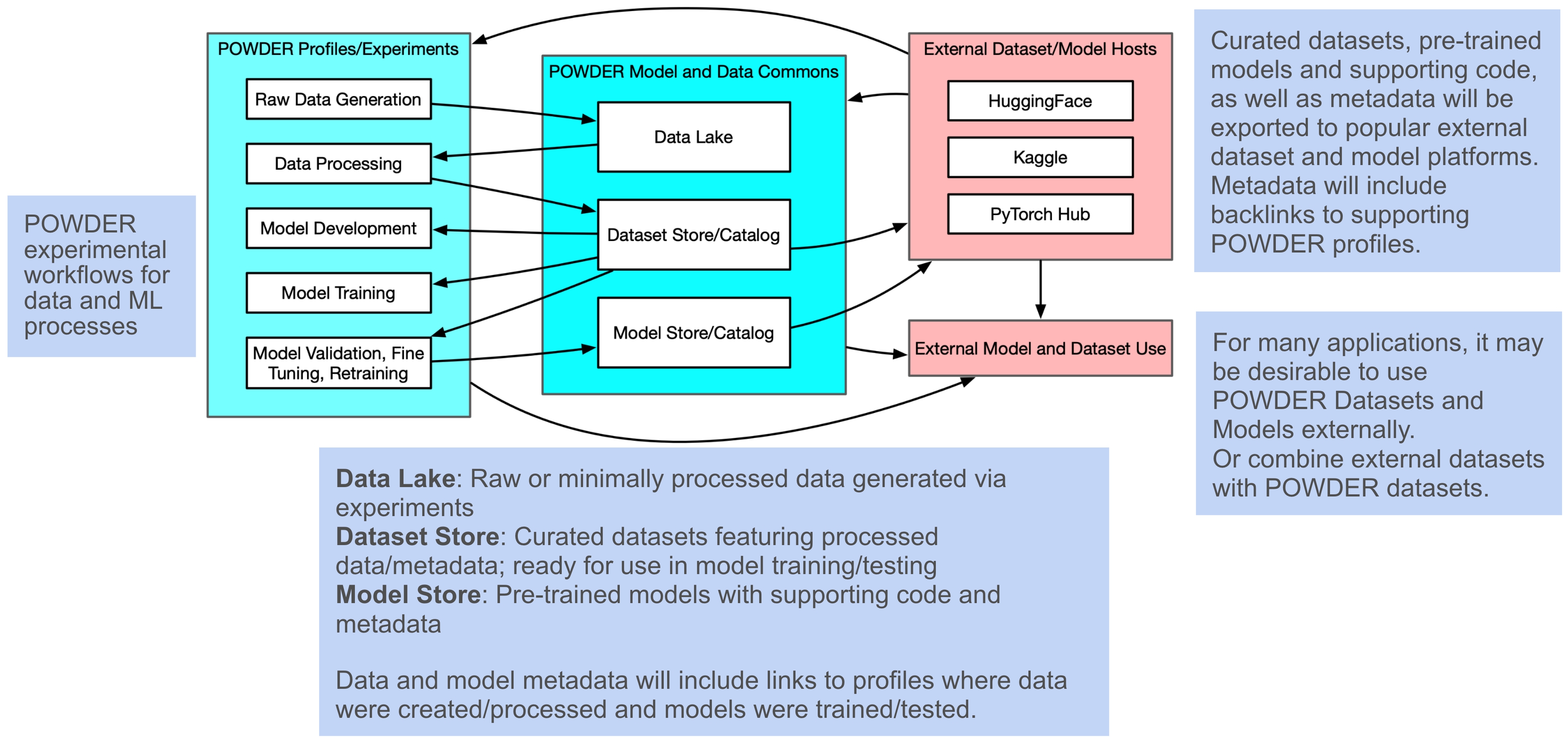
To simplify the collection and processing of data on POWDER, and to enable AI/ML use cases and workflows in a real world wireless environment, we are developing the POWDER Model and Data Commons architecture.
As shown in the figure below, this framework allows for data capture from POWDER experiments into a data lake, for data exploration and processing of the data in the data lake, for model development, training and validation on POWDER, and for interfacing with external datasets and AI/ML frameworks.
As we continue to develop this framework, we will be adding datasets and models generated using the POWDER Model and Data Commons below, together with other POWDER datasets (from the POWDER team and from POWDER users).
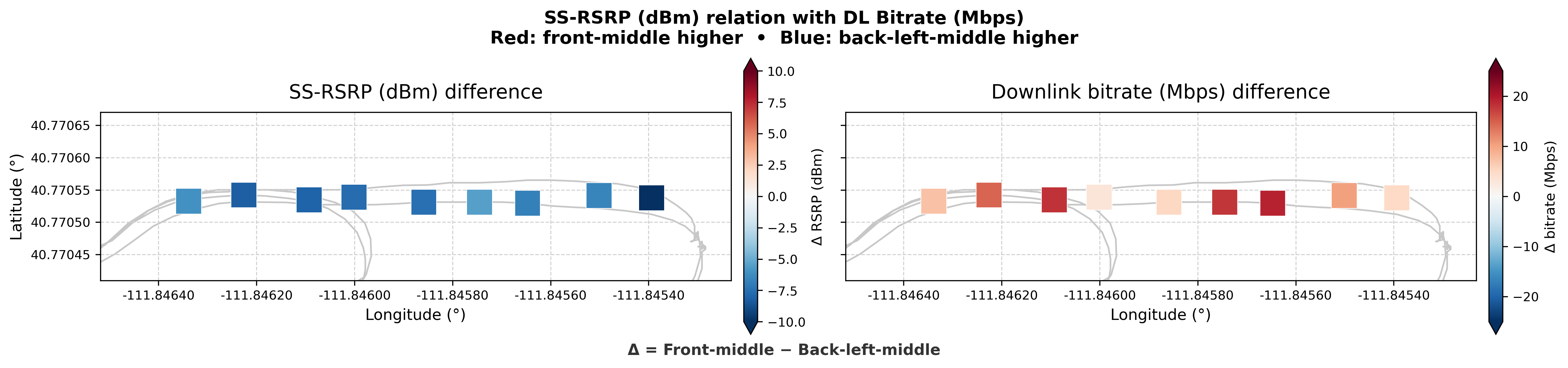
The "wireless analysis" objective of this dataset is to explore the impact of vehicle antenna placement on the wireless performance of a mobile UE.
The dataset also serves to illustrate aspects of the POWDER Model and Data Commons. Specifically the ability to stream data from multiple data sources into a data lake for cross dataset analysis.
The linked Zenodo dataset contains pointers to a POWDER profile that enables POWDER users to instantiate their own small data lake (a data pond...) containing the data and processing scripts.
| Date Collected | October 2026 |
|---|---|
| View/Download | https://zenodo.org/records/23603729 |
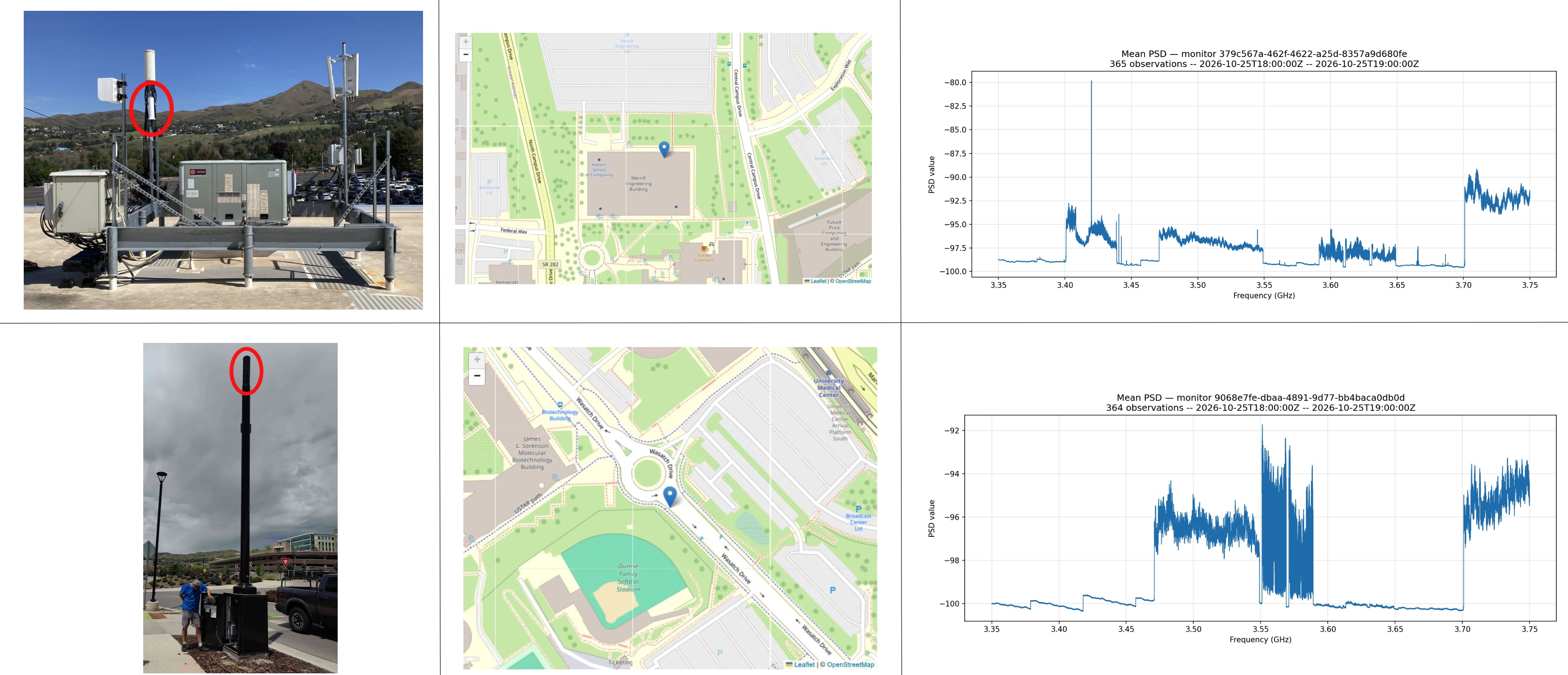
Raw power spectral density files produced by two calibrated Signal Hound SM200C RF monitors deployed in the POWDER testbed on the University of Utah campus in Salt Lake City, UT. The dataset is a collection of Parquet files, collected over a one-week period, partitioned by monitor_id, with each row containing a SigMF metadata column and a raw data column with an array of RF32 little-endian floating-point power values per frequency bin, as well as associated metadata (e.g. starts_at and ends_at define the time bounds of the sweep that produced each PSD). The goal of this dataset is to help researchers analyze spectrum occupancy and utilization in the POWDER platform, and to allow them to develop and test spectrum occupancy prediction models.
The data were collected on POWDER, the Platform for Open Wireless Data-driven Experimental Research (https://powderwireless.net): a city-scale, remotely accessible wireless testbed at the University of Utah in Salt Lake City, one of the US National Science Foundation's Platforms for Advanced Wireless Research (PAWR). The data were collected via the OpenZMS spectrum management system, which was developed as part of the POWDER-RDZ project and resulted in a functional radio dynamic zone deployment in POWDER. OpenZMS provides advanced spectrum monitoring and spectrum sharing capabilities, and through its integration with POWDER which resulted in POWDER-RDZ, provides these spectrum capabilities to POWDER users.
| Date Collected | October 2026 |
|---|---|
| View/Download | https://zenodo.org/records/23789378 |
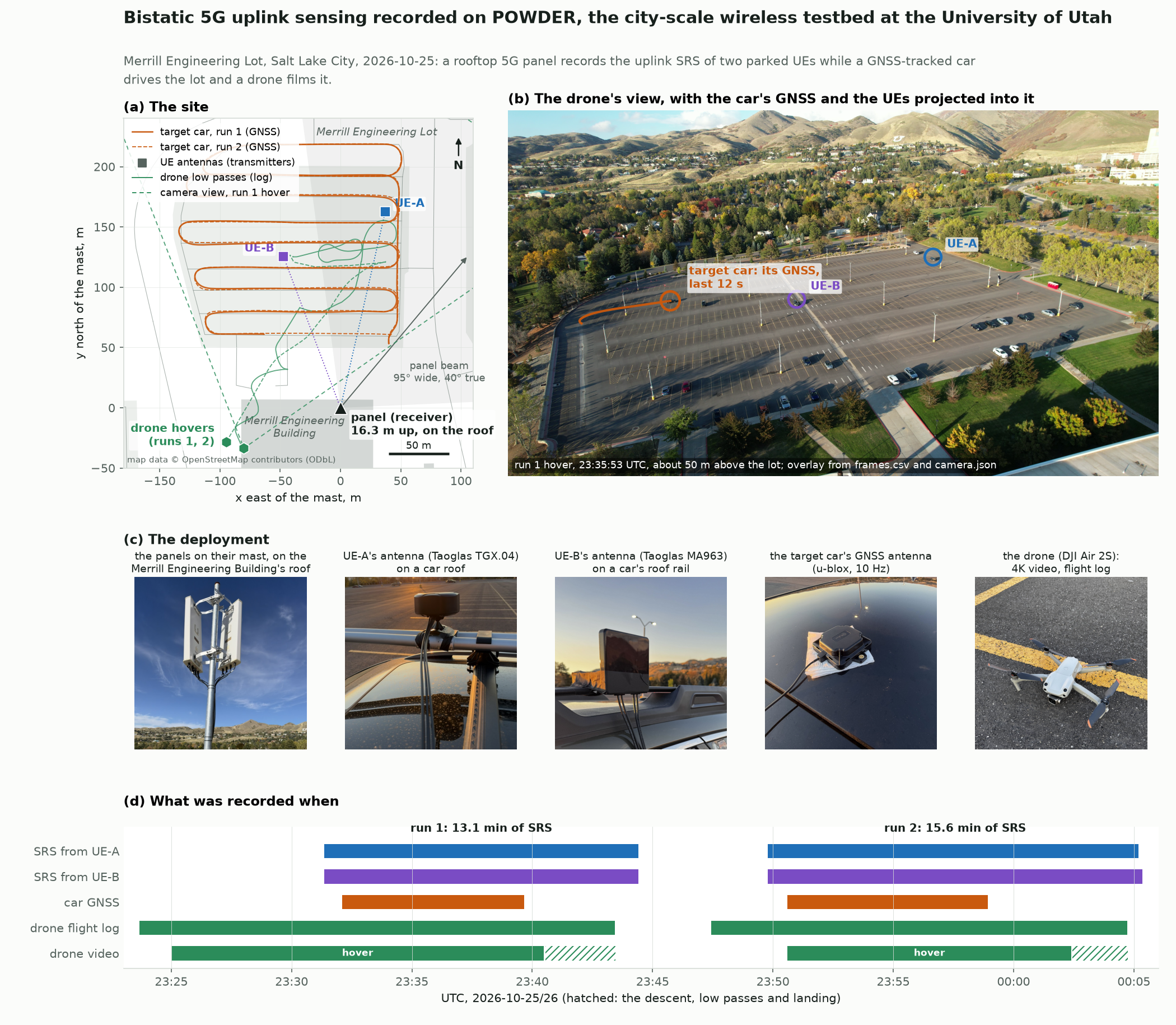
Raw 5G uplink sounding reference signals (SRS) received by a base station, recorded for sensing. In two runs, a 5G NR base station received the SRS of two parked UEs (Quectel RM520N-GL cellular modems on car roofs) every 2.5 ms, on a four-port panel overlooking a parking lot. Every SRS was recorded raw: the received resource elements on all four receive ports, the reference sequences, and the exact air time. Meanwhile a car carrying a GNSS receiver drove a planned route through the lot, and a drone filmed the lot from a hover and then flew low passes.
Each SRS travels from a UE to the antenna panel along the direct path and, more faintly, by way of everything that reflects it. A moving reflector (the car, the drone, people, other cars) adds an echo whose delay and Doppler shift change over time. That makes the record a bistatic sensing dataset, with two transmitters and one four-port receiver. The ground truth is the car's GNSS, the drone's flight log, and the video with a timed camera pose for every frame.
| Date Collected | October 2026 |
|---|---|
| View/Download | https://zenodo.org/records/23717707 |
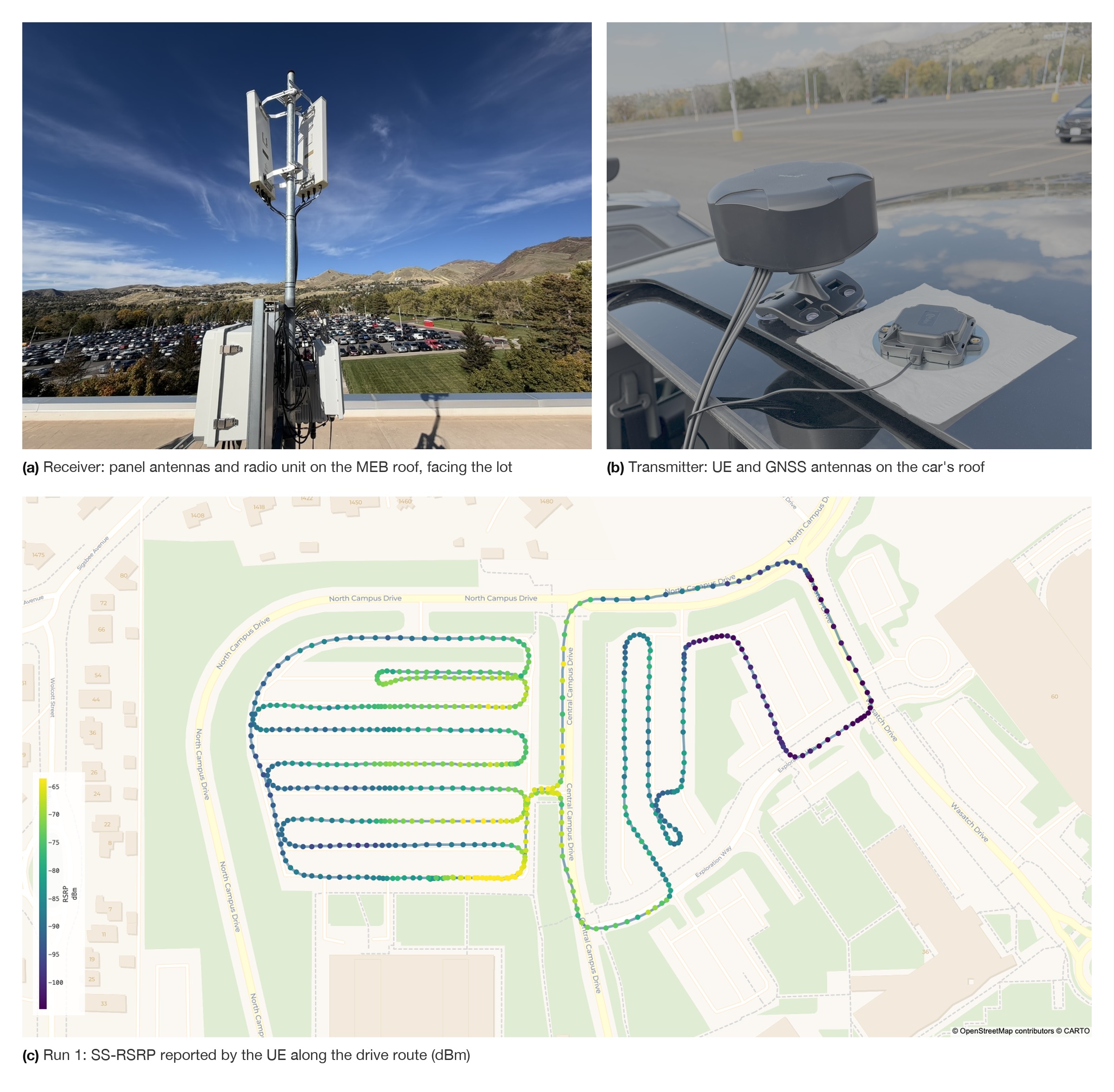
Raw 5G uplink sounding reference signals (SRS) from a UE driving through the Merrill Engineering Building (MEB) parking lot, as received by a base station. The setup consists of a car driving along a preplanned route on the University of Utah campus with the UE's antenna and GNSS receiver mounted on the roof of the car. Two runs were collected where a 5G NR base station (on the roof MEB) received SRS from the mobile UE every 10ms. All SRS kept by the base station were recorded raw: the received resource elements on both receive ports, the reference sequences, the SRS configuration, and the frame, slot, and capture time. The UE logged its side of the link with Keysight Nemo Outdoor: time-stamped, GNSS-tagged layer 1 to layer 3 measurements and signaling, from radio measurements, link adaptation and throughput to RRC and NAS events.
| Date Collected | October 2026 |
|---|---|
| View/Download | https://zenodo.org/records/23741918 |
RX I/Q data from 0 to 4 simultaneous OFDM interferers using 5 dense deployment nodes on Powder.

| Date Collected | 2026 |
|---|---|
| View/Download | Multiple interferers data |
This dataset was collected using G-NetTrack Pro on a Samsung Galaxy S23 Ultra while driving between Salt Lake City, Utah, USA, and Scipio, Utah, USA. The collected data consists of: (1) Spectrum measurements, such as frequency bands, RSRP, and RSRQ. and (2) Event measurements, such as 5G-to-5G handover. All measurements are associated with a location (latitude, longitude, elevation).

| Date Collected | March 2026 |
|---|---|
| View/Download | Usage data |
This dataset was collected during a series of drive tests conducted between two sites near the University of Utah, using a Quectel RM500 user equipment (UE) device and srsRAN gNBs (version 24.10), along with Nemo (Keysight) measurement tools. The data is organized into two tables: (1) gNB-side measurements, which include timestamped records of serving and neighboring cell identifiers along with their corresponding RSRP values, and (2) UE-side measurements, which capture the time, GPS location (latitude and longitude), serving and neighboring physical cell identities (PCI), and the RSRP values observed at the device.
| Date Collected | January 2026 |
|---|---|
| View/Download | Handover data |
Built on the POWDER-FRS outdoor RSS dataset (462.7 MHz, campus scale) using our ACM CoNEXT 2025 tool (PhARMNet). This dataset combines real RSS measurements, DSM/building maps, and TIREM-derived terrain features to synthesize RSS at unseen transmitter locations.

| Date Collected | 2025 |
|---|---|
| View/Download | Localization data |
This dataset was collected using a Viavi CA5000 spectrum analyzer and a GPS application on a Motorola Edge, while driving around the University of Utah campus. The collected data consist of two measurement tables: (1) Spectrum measurements, with per-channel SS-RSRP and SS-SINR for Verizon and CBRS GAA channels, and (2) GPS measurements, capturing the location (latitude, longitude, elevation) where the spectrum measurements took place.
| Date Collected | 10/22/2025 |
|---|---|
| Date Released | 1/16/2026 |
| Version | 0.1 |
| File Size | 2.2 MB |
| File Download | https://zenodo.org/records/18272105 |
This dataset contains channel measurements from a measurement campaign conducted on the University of Utah campus for determining the placement of three massive MIMO base stations. The exercise also shows the viability of over a dozen candidate endpoint sites. This dataset is comprised of LTS frames sent by a transmitter that was moved from position to position (endpoint locations). These frames were measured at radio receivers on five candidate rooftop locations. Candidate rooftop sites (receivers) and potential endpoints locations (transmitter) are shown on the following map:

| Date Collected | 09/23/2020 |
|---|---|
| Date Released | 10/26/2020 |
| Version | 0.1 |
| File Size | 5.3 GiB |
| File Download |  |
We frequently perform spectrum scans from all available POWDER nodes. The scans cover all sub-6GHz frequencies. The resulting data is archived and can be downloaded for analysis. The data is also useful to look at activity within the bands POWDER can operate in.
| Date Collected | Since August 2020 |
|---|---|
| View/Download | Scanning data |
This dataset was collected on the POWDER platform by the GENESYS Lab at Northeastern University.
This dataset is supplementary to the article 'G. Reus-Muns, D. Jaisinghani, K. Sankhe and K. R. Chowdhury, "Trust in 5G Open RANs through Machine Learning: RF Fingerprinting on the POWDER PAWR Platform," IEEE Globecom, 7-11 December 2020, Taipei, Taiwan.'
| Date Created | 09/10/2020 |
|---|---|
| File Download | POWDER-4BS-IQsample |
This massive MIMO dataset was collected by the RENEW team from Rice University using a mMIMO array set up in an anechoic chamber at the POWDER platform. In Full-Duplex systems, one of the main challenges is self-interference where outgoing transmissions essentially "drown" the incoming signals. This dataset measured the self-interference across all radios on a massive MIMO base station comprised of 48 radios. The RENEW Sounder tool was used to continuously send pilots from each antenna, in round robin fashion, while all other antennas listened to those transmissions.
| Date Created | 17/11/2021 |
|---|---|
| File Download | Full-Duplex Massive MIMO dataset |